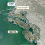
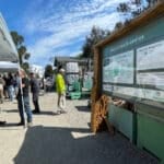
On September 27, the Sea Level Rise Planning Fair at the REAP Climate Center presented the City’s draft sea level rise strategies by neighborhood, including for the Northern Waterfront, the East End and Tidal Canal, Alameda Point and the West End, South Shore, and Bay Farm Island. Alameda residents were invited to share ideas, concerns, and hopes for the future of the waterfront as part of developing an Alameda Shoreline Adaptation Plan.


OACC and Shoreline Adaptation Plan
The fair was hosted by the Oakland Alameda Adaptation Committee (OACC), a coalition working to accelerate sea level rise adaptation, protect and restore water quality, recreation, and habitat, and enhance resilience along the Oakland-Alameda shoreline. It includes local jurisdictions, agencies, and community-based organizations as well as regional, state, and federal collaborators. Sea level rise adaptation requires cross-jurisdictional planning, since flooding doesn’t respect jurisdictional boundaries.
The fair’s goal was to receive community feedback on the draft Shoreline Adaptation Plan that the City of Alameda is developing using guidelines established by the Bay Conservation and Development Commission. The City is in the middle of its four-year development process.


Hazards and vulnerabilities
OACC notes that the changing climate is changing the entire water cycle. Sea levels are rising, groundwater tables are rising, and precipitation intensity is increasing. Alameda, for instance, saw wave overtopping and coastal flooding during the January 2024 storms.
As these risks increase over time, impacts on the community increase. Without adaptation, rising seas and coastal flooding can overtop shorelines and spread to low-lying inland neighborhoods. Rising groundwater, pushed to the surface by rising sea levels, can impact communities from below, damaging underground infrastructure, mobilizing contaminants, and increasing liquefaction rates during earthquakes. Developments on landfilled areas that were formerly tidal marsh or mudflats are especially vulnerable.


Adaptation strategies
The City has defined an adaptation zone. Although major changes won’t happen everywhere in this zone, much of the shoreline and low-lying inland areas will need to be adapted to manage future flooding. Potential solutions include physical, policy, and nature-based strategies.
Potential Physical Strategies
| Strategy | Description | Examples | Key Considerations |
|---|---|---|---|
| Do Nothing | Community takes no proactive actions; instead, reacts once impacts occur. | Emergency responders address disasters; infrastructure owners maintain existing systems. | Reactive approach, no risk reduction until after impacts occur. |
| Accommodate | Anticipate risks and reduce flood consequences through adaptive measures. | Building retrofits, moving sensitive equipment, upgrading warning systems. | Focuses on minimizing damage rather than preventing floods. |
| Shoreline Protection | Create physical barriers at the shoreline to protect people and property. | Seawalls, levees, floodwalls, wetlands, living seawalls, coarse beaches. | Requires stormwater system upgrades inland to prevent inland flooding. |
| Shoreline Redevelopment | Redevelop and elevate shoreline areas at risk to protect the broader community. | Raised developments coordinated with property owners, City, and development partners. | Needs coordination to ensure consistent standards and avoid protection gaps. |
| Retreat (Inland Migration) | Move people and infrastructure out of high-risk areas, enabling ecological restoration opportunities. | Converting paved runways into tidal wetlands at Alameda Point. | Long-term strategy; reduces risk while supporting ecosystem recovery. |
Examples of policy strategies include updating land-use plans and building codes, as well as developing guidance on sea level rise.
Nature-based solutions are also vital. Much of Alameda is on land that was previously tidal marsh, mudflat, or open water. As the city has grown, it has lost landscapes critical to its resilience.
Numerous opportunities exist to expand habitat areas for flood protection and ecological benefit. Oyster beds, fringing tidal marshes, beaches, and eelgrass beds all deliver benefits—from reducing wave energy and erosion to improving water quality, sequestering carbon, and supporting a diverse array of wildlife species.

Adaptation strategies by reach
For the purposes of adaptation planning, the City has broken down the Alameda shoreline into areas called “reaches” that roughly correspond with local watershed boundaries.

East End and Tidal Canal
While the East End and Tidal Canal shoreline is relatively sheltered from wave hazards, risks include king tide flooding and storm-driven inundation of low-lying residential neighborhoods and streets. With one foot of sea level rise projected between 2040 and 2060, over 300 homes could be impacted.
Near-term adaptation emphasizes voluntary retrofits by property owners—such as elevating structures or adding floodwalls—alongside City-led measures like improved stormwater management. Despite these challenges, adaptation may also bring opportunities for positive change, such as increasing public access to the waterfront.
By 2070 to 2100, with up to three feet of sea level rise, more than 650 homes could be affected, and private adaptation alone will not suffice. Collective, community-scale strategies will be required.

Northern Waterfront
The Northern Waterfront is undergoing a significant transformation from former shipbuilding and industrial uses to residential, commercial, and recreational development. As this neighborhood continues to evolve, there are opportunities to reduce risk while providing co-benefits. For example, the Alameda Marina, Encinal Terminals, and Alameda Shipways developments will follow the City’s adaptation requirements and incorporate waterfront public improvements, including Bay Trail extensions.


With one foot of sea level rise projected between 2040 and 2060, over 190 homes could be impacted. Near-term projects include measures to address coastal flooding and inland stormwater management. For example, the Estuary Project, endorsed by the City Council in 2025, proposes the construction of levees, seawalls, and inland stormwater basins to reduce risks near the Posey and Webster Tubes.
By 2070 to 2100, with three feet of sea level rise, over 390 homes could flood, requiring expanded shoreline defenses, marina adaptations, and large-scale stormwater management.

South Shore
The South Shore area is highly vulnerable to flooding. Currently, extreme storms and king tides already threaten homes and streets. With one foot of sea level rise by 2040 to 2060, over 800 homes could flood. Near-term strategies emphasize nature-based adaptation, such as strengthening Alameda Beach and the Elsie Roemer Bird Sanctuary through dune building, marsh restoration, sand replenishment, and intertidal enhancements. These natural buffers protect Shoreline Drive, the Bay Trail, and adjacent neighborhoods. Additional measures include stormwater improvements, lagoon dredging, and voluntary floodproofing of private properties.
By 2070 to 2100, with three feet of sea level rise, more than 1,800 homes could be impacted. At that point, larger interventions—such as levees, inland flood defenses, or changes in land use—may be necessary. A critical tipping point occurs at two feet of sea level rise, when Alameda Beach may no longer provide adequate protection.

Alameda Point and West End
Alameda Point and the West End are low-lying shoreline areas with a history of dramatic transformation, from tidal marshes to the Naval Air Station, and now to redevelopment under the Alameda Point Master Infrastructure Plan (MIP). Much of the shoreline is already vulnerable to coastal flooding.
The MIP incorporates levees, raised development, and stormwater management to protect new housing, commercial, and open space areas, while balancing ecological restoration such as the De-Pave Park wetlands.
Managed retreat is envisioned west of Monarch Street, converting paved runways into tidal wetlands while preserving public access and habitat. The West End, with its mix of residential and maritime-industrial uses, requires coordinated adaptation with the U.S. Army Corps’ Port of Oakland Turning Basin project. Cleanup of contaminated sites remains critical to long-term resilience.

Bay Farm Island
Bay Farm Island is a low-lying neighborhood that faces significant risks of coastal, inland, and groundwater flooding. Its western shoreline is vulnerable to wind-driven waves, while San Leandro Bay faces storm surge impacts. Inland areas, especially the Maitland Drive neighborhood, are already at risk due to low elevation and outdated drainage systems.
With one foot of sea level rise between 2040 and 2060, over 1,400 homes could flood during extreme storms. Near-term strategies focus on levee improvements, pump station upgrades, roadway elevation enhancements, and nature-based shoreline features, including gravel beaches, marsh expansion, and cobble headlands. The Northern Shoreline Project, endorsed in 2025, proposes the construction of levees, habitat enhancements, and upgrades to the Bay Trail.
By 2070 to 2100, with three feet of sea level rise, more than 3,400 homes could be impacted. Long-term measures may include larger levees, expanded lagoons for stormwater management, and potential land use changes in high-risk areas.

What’s next
Earlier this year, the City lost a FEMA (Federal Emergency Management Agency) BRIC (Building Resilient Infrastructure and Communities) grant worth approximately $54 million to address sea-level rise and flooding due to the federal government’s elimination of the BRIC program. Danielle Mieler, City Sustainability and Resilience Manager, noted, “We’re looking at lots of other funding sources, mostly state and regional funding opportunities. Probably, there’s nothing to replace the size and scale of what federal funding can provide. So we’re going to be breaking the projects down into smaller phases and pieces.”
Mieler added that community input is central to the planning process. In addition to the fair, materials from the event will soon be available online as PDFs for public review. Additionally, an online survey will launch in the coming weeks for those who were unable to attend the fair.
In December, staff will brief City Council on accomplishments and feedback received to date.
Contributing writer Karin K. Jensen covers boards and commissions for the Alameda Post. Contact her via [email protected]. Her writing is collected at https://linktr.ee/karinkjensen and https://alamedapost.com/Karin-K-Jensen.
