A slow-moving ecological disaster is underway along the shoreline from Park Street to near the Bay Farm Island Bridge, an area that normally is covered with marsh vegetation that shorebirds rely on as feeding habitat.

“We live adjacent to Alameda’s bird sanctuary and are seeing it being taken down by the large washup of sand from Crown Beach,” wrote Lisa Ferguson in an August 8, letter to the Alameda Post. You don’t have to take her word for it. Google Earth historical imagery shows the footprint of the encroaching sand, right up to the most recent image from May 30, 2025. Visit the shoreline trail and you will see that the sandbar has moved the length of three residential lots in less than three months, destroying marsh vegetation in the process.
The powerful storms and tides that caused major damage to Alameda’s south shoreline in October 2021 and December 2024 may explain why such a large volume of sand is being deposited onto the nearby marshland right now. So much sand was washed away in December that cliffs were carved into the dunes, and the corner of Shore Line Drive and Westline Drive required emergency repairs. The sand left the beach, but apparently it didn’t go far. It merely moved out into the path of tidal currents.

Google Earth’s historical imagery can provide recent reference points for what the Elsie Roemer Bird Sanctuary and adjacent natural habitat once looked like when it was mainly salt marsh. Today, the shoreline in front of the observation deck over the bird sanctuary is becoming a sand beach.
In recent years, 97% of an invasive marsh grass has been eradicated around San Francisco Bay, including on Alameda’s southern shoreline, because it outcompetes other marshland plants that provide shelter for shorebirds, and that reduces the prevalence of shorebird food sources such as worms, crabs, and snails. Native marsh grass, called Pacific cordgrass, was planted to re-establish beneficial wildlife habitat. Now, however, the nascent patches of native marsh grass on Alameda’s shoreline are at risk of total loss from sand inundation, along with another salt marsh plant, pickleweed, where birds often forage for food.
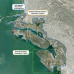
Fortunately, there will be an opportunity in the coming months to address this slow-moving ecological disaster when the long-term Regional Shoreline Adaptation Plan for the southern shoreline is considered.


One of the purposes of the adaptation plan is to “create or restore marsh, upland and transitional habitat with nature-based solutions.” It will be crucial to the long-term success of the plan that the shoreline from Crab Cove to the Bay Farm Island Bridge is viewed holistically. Three key questions for planners to address were identified in the City’s recently updated Climate Adaptation and Hazard Mitigation Strategy: How much of Crown Beach must be maintained as a beach to continue providing recreational benefits? Can the ecosystem services that the beach, dunes, and marsh provide be quantified and can a system be established to pay for their maintenance? How will tidal wetlands habitat be incorporated into the adaptation plans for the shoreline?
Seeing our salt marsh transformed into a sandbar shows that the beach and salt marsh cannot be compartmentalized. Continually barging in sand to replenish the beach without an engineered solution to keep it from ending up on sensitive habitat is a recipe for killing the bird habitat.


In keeping with the adaptation goal to “create or restore marsh,” expanding the Elsie Roemer Bird Sanctuary is worth considering. Currently, the official sanctuary boundaries are the concrete pier-like structure next the beach restroom at the end of Park Street and the chain-link fence at the end of Broadway, even though the actual marsh bird habitat continues on toward the bridge along the backyards of residences.


The low-lying beach next to the sanctuary also is worth considering for creating new marsh and transitional habitat. Currently the dune grass is not popular with migrating birds, nor with visiting sunbathers and, in any case, will one day be underwater without a new plan.
As background for the current adaptation planning, it is worth looking at the shoreline study done 45 years ago by the Army Corps of Engineers. There was an alternative to creating a continuous recreational sand beach that covered up 11 acres of mudflat. The alternative was dubbed the “Environmental Quality Plan” because it would lead to expansion and enhancement of wildlife habitat, while providing long-term protection of Shoreline Drive.
To learn about local risks, explore climate adaptation solutions, and share your ideas for protecting our communities and natural spaces, there are two events in September worth putting on your calendar. On Saturday, September 20, 9 to 11 a.m., Community Action for a Sustainable Alameda (CASA) will be hosting a walk along the shoreline from 3315 Bridgeview Isle near the Bay Farm Island Bridge to Elsie Roemer Bird Sanctuary, and on Saturday, September 27, the REAP Center at 2133 Tynan Avenue will host a drop-in Adaptation Planning Fair from 10 a.m. to 1 p.m.
Contributing writer Richard Bangert posts stories and photos about environmental issues on his blog Alameda Point Environmental Report. His writing is collected at AlamedaPost.com/Richard-Bangert.
Editorials and Letters to the Editor
All opinions expressed on this page are the author's alone and do not reflect those of the Alameda Post, nor does our organization endorse any views the author may present. Our objective as an independent news source is to fully reflect our community's varied opinions without giving preference to a particular viewpoint.
If you disagree with an opinion that we have published, please submit a rebuttal or differing opinion in a letter to the Editor for publication. Review our policies page for more information.
